
Forests Monitor

“The production forest is, after all, quite boring for a planner” - Integrating landscape perspective in forest planning under laissez-faire governance
“The production forest is, after all, quite boring for a planner” - Integrating landscape perspective in forest planning under laissez-faire governance
Anna Karlsson, a* Vilis Brukas, a
a: Swedish University of Agricultural Sciences, Department of Southern Swedish Forest Research Centre, Alnarp, Sweden.
*Corresponding author: E-mail: [email protected]
Citation: Karlsson A, Brukas V. 2026. “The production forest is, after all, quite boring for a planner” - Integrating landscape perspective in forest planning under laissez-faire governance. For. Monit. 3(1): 1-43. https://doi.org/10.62320/fm.v3i1.29
Received: 5 February 2026 / Accepted: 9 Jue 2026 / Published: 23 June 2026
Copyright: © 2026 by the authors
ABSTRACT
The importance of a landscape scale for multiple benefits is well established; yet the adoption of a landscape perspective in forest management constitutes a formidable challenge, especially in countries where forest governance rests on a laissez-faire approach, and forests are dominated by non-industrial private landowners. Forest management plans (FMPs) constitute a viable, if often overlooked, option for better accommodating the increasingly diverse needs of forest owners and improving consideration of the landscape scale. With the southern Swedish forest owner association Södra as the case, this study investigates the key challenges of advancing FMPs in these respects. We consider forest management planning as a nested human endeavour, where agency of planners and owners is embedded in particular organisational and governance contexts. In-depth interviews and ethnographic observations at Södra reveal that, despite improvements in the status and capacity of forest planning, considerable scope remains for better eliciting and accommodating owners’ needs at planners’ front-office. Regarding the landscape perspective, major hinders lie in the back-office, including outdated planning templates, a lack of harmonised data, and a lack of tailored planning software. The study concludes by discussing potential remedies at organisational and governance levels.
Keywords: back- and front-office, forest landscape scale, forest management plans, Sweden
INTRODUCTION
There is no universal measure for defining a landscape. Its delineation is inherently situational and depends on the subjective judgement of a landscape user for a given purpose (Council of Europe Landscape Convention, 2000). Accordingly, landscapes can range from several hundred to many thousand hectares, considerably exceeding the average estate size of Swedish non-industrial private forest owners, which currently averages 34ha (SFA, 2024a). An extensive body of scholarship shows that biodiversity outcomes and many ecosystem services depend on processes operating at the landscape scale rather than at the stand or estate level (Brockerhoff et al. 2017). This underscores the need for multiscale planning and conservation measures (Felton et al. 2020), as well as the coordination of forestry practices across spatial and temporal scales that extend beyond estate boundaries (Fischer 2018, Michanek et al. 2018). Yet adopting a landscape perspective remains particularly challenging in countries with laissez-faire forest governance systems, where forests are dominated by non-industrial private landowners[1] (Mayer 2019) with few dos and don’ts (Brukas et al. 2013), such as southern Sweden, where 77% of the forest area is in the hands of small-scale owners (SFA, 2024a).
One approach to address a landscape scale is through adopting public participation in forest planning (Buchy and Hoverman 2000). Numerous instances of participatory processes for enhancing the multiple values from forested landscapes can be found in the establishment and management of protected areas (e.g. Sandström and Sahlström 2021) or urban forests (e.g. Nordström et al. 2010), but these cases are typically ad hoc and triggered locally by land-use conflicts or high amenity values. In more ordinary landscapes, the development of green infrastructure[2] plans represents the most comprehensive attempt to Swedish landscape planning to date. By 2020, the majority of Swedish counties had successfully prepared such plans (Guillén et al. 2026), yet implementation has been close to non-existent for multiple reasons, including insufficient resources, distrust among actors, and inadequately designed collaborative processes (Karlsson et al. 2024), resulting in a pronounced disconnect between these plans and practical forest management (Elbakidze et al. 2018).
Landowner cooperation represents another potential pathway for coordinating management across estate borders (Kittredge 2005). In Sweden, three forest owner associations unite around half of the small-scale private owners and have achieved remarkable economic success, including the development of their own timber processing industries. However, when procuring timber from their members, associations’ operational priorities remain primarily focused on economic efficiency and service provision at the stand or estate level, with limited attention to landscape-level considerations (Curtis et al. 2023).
A more explicit integration of a landscape perspective in conventional forest management plans (FMPs) for small-scale[3] owners represents a promising yet often overlooked option for enhancing landscape values, if adopted widely (e.g. Tikkanen et al. 2010, Pynnönen 2020). Although FMPs are not obligatory under Swedish legislation, around two-thirds of non-industrial private forests are covered by valid[4] plans, 7.2 million ha (SFA, 2026). At their core, FMPs serve as decision-support tools for forest owners, yet Brukas and Sallnäs (2012) found that their advisory potential was underutilised, due to insufficient interaction between planners and owners and the dominant industrial orientation of the private planning organisations. Owners’ objectives, on the other hand, typically extend well beyond timber revenues to encompass a range of other services (Weiss et al. 2019, Lidestav and Westin 2023). These objectives increasingly align with societal demands for multiple ecosystem services, highlighting the need for more explicit landscape-level consideration in forest management planning.
Drawing on the multi-scale perspective adopted in landscape ecology, this study conceptualises the landscape perspective to comprise two levels (cf. Paltto et al. 2006). The regional landscape refers to the broader socio-ecological context in which societal priorities and landscape identity are expressed. It can be characterised through regionally relevant indicators, such as valuable forest habitats and cultural heritage features. The local landscape refers to the immediate surroundings of a forest estate, encompassing neighbouring land uses, ecological features, and social values that may shape management opportunities and constraints. At this scale, management decisions are influenced by site-specific conditions, spatial relationships with adjacent areas, and forest owners' relationships to locally important values (Antrop and Eetvelde 2017). It is particularly at this level that we can speak of meaningful spatial attributes in situ, e.g. promoting spatial connectivity between valuable habitats or streams (Michanek et al. 2018); influencing forest structure and composition (Messier et al. 2019); promoting recreation infrastructure such as hiking trails (Johnsson and Beery 2023).
Using the case of Södra, forest owner association that is the largest organisation in terms of forest planning for private small-scale owners in southern Sweden, this study examines the organisational, social, and technical conditions shaping planners’ capacity to accommodate forest owners’ multiple values and needs, and to integrate a landscape perspective in FMPs for small-scale estates, and discusses implications and options for improving planning practice in this regard. Drawing on the back- and front-office distinction in service-providing organisations (Labarthe and Laurent 2013, Li et al. 2014), the analysis focuses on: (i) support functions for forest management planning in Södra’s back-office; and (ii) front-office interactions between planners and forest owners. This exploratory inquiry thereby addresses a significant gap in understanding the challenges of landscape-level stewardship under laissez-faire governance and in forested landscapes characterised by small-scale ownership.
THEORETICAL UNDERPINNINGS
At its operative core, forest management planning comprises a set of actions by the forest planner that culminate in an FMP for the given planning unit. Irrespective of the ecological conditions or other features of an estate, the elaboration of an FMP is typically conducted in three phases. During the preparatory phase, a planner gathers available information, such as existing data on the forest estate and attempts to clarify forest management priorities by the owner or manager in question. Next, the planner conducts fieldwork, i.e., makes a forest inventory. As a minimum, the planner estimates basic forest parameters such as tree species composition, prevailing age and standing volume. An important part of the inventory is assessing the degree of spatial homogeneity, enabling the delineation of forest stands as the main spatial unit for planning concrete management measures. Finally, in the wrap-up phase, an FMP is elaborated, including the description of the current forest state, spatial visualisations through maps, and management proposals for each stand (see further details in Supplementary material A).
The planning process, and especially the degree of interaction between the planner and the owner, might vary, depending on, e.g. the individual characteristics of these agents (Brukas and Sallnäs 2012). Nevertheless, much of the forest planning literature conceptualises the production of FMPs as primarily a standardised, technical, and information-driven endeavour, emphasising optimisation methods, forest information systems, and planning technologies (Bettinger et al., 2017; Baskent et al., 2024). Planning outcomes are therefore often understood as dependent on the availability and quality of forest information, as well as organisational and technological resources (Ulvdal et al. 2023).
Such a view, however, neglects the embeddedness of forest planning in a particular institutional and cultural context. As shown in a comparative study of 31 European jurisdictions, the purpose and outcomes of planning can radically differ depending on the legal and institutional framework (Nichiforel et al. 2018). In strictly regulated systems, as in many Eastern European countries, FMP primarily serves as a regulatory tool, operationalising legal stipulations into commands for specific forest management measures. Under a liberal governance, as in Sweden, FMP is more likely to serve as an informational tool, e.g. as a decision aid for a forest owner (Brukas and Sallnäs 2012). Further, a planner’s agency is to a large extent framed by the interests and routines of the planner’s organisation (e.g. Arts et al. 2014, ter Bogt and Scapens 2019). Thus, to properly understand the makings and the outcomes of FMPs, we need to duly consider societal and organisational contexts (Figure 1). For the purpose of this study, the governance context is described in the Section “The southern Swedish case study”, while the rest of this section elaborates theoretical underpinnings for studying the organisational context.
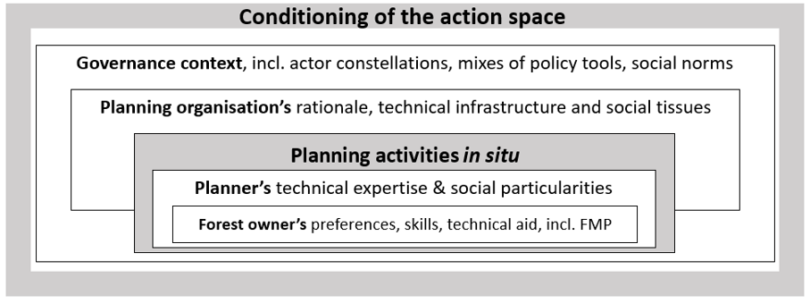
Figure 1. Forest planning as a socially and technically embedded practice. Interactions between planners and forest owners are situated within planning organisations and conditioned by broader governance arrangements, which together shape the action space for forest management planning.
Whatever the purpose of planning, an FMP is essentially a service provided by a planning organisation to the forest owner. Organisations can be of different types, ranging from a small private company specialised in forest planning to a large multi-service organisation, where forest planning is only one of many offered services, with widely different rationales, routines and capacities (Bettinger et al. 2017). To nuance the functional conditioning of planning, it is useful to differentiate back- and front office of the organisation (Labarthe and Laurent 2013). The co-production of knowledge takes place at the front-office, where planners, the key figures in a planning organisation, interact directly with forest owners to define their objectives and discuss management options (Table 1). In contrast, the back-office provides indirect, behind-the-scenes support and services, facilitating the front office’s operations (Li et al. 2014). Recognising this interplay underscores the importance of attending to planners’ needs as social actors operating within socio-technical systems. Planners’ ability to routinely perform planning activities is contingent not only on the technology itself but also on how well it aligns with their social and organisational context (Appelbaum, 1997).
Table 1. Back- and front-office features of a planning organisation.
|
Back-office |
Front-office |
|
- Organisational interests and motivations - Status and positioning of the planning branch in the organisation - Technical infrastructure and support |
- Planner’s values and priorities - Planner’s technical and social competencies - Modes of interaction between planner and owner |
In the context of forest planning at Södra, the back-office (i.e., support functions or units) enhances the efficiency and accuracy of the front-office (planners) through the provision of technical tools, educational resources, procedural templates, and other necessary support mechanisms. Good alignment between back- and front-offices is essential for providing high-quality service to customers (Mach et al. 2006, Zomerdijk and de Vries 2007), i.e. forest owners in our case. A careful examination of the back- and front-office is thus instrumental for understanding the true potential of meeting the multifaceted needs of owners, or, for that matter, better integration of landscape perspective in FMPs. Though, to our knowledge, no study in forest planning to date has explicitly adopted the back- and front-office dichotomy, interesting parallels can be drawn from a Finnish study by Pynnönen (2020). Forest planners in Finland recognised the necessity to be more responsive to different needs of owners, but prevailing organisational alignment, such as IT systems at the back-office, were primarily oriented toward timber procurement.
THE SOUTHERN SWEDISH CASE STUDY
The last major change to Swedish forest policy in 1993 entailed two somewhat conflicting goals. The importance of environmental values was equalised to forest production, in a sharp contrast to previous, production-oriented policies. At the same time, forest policy underwent deregulation, leaving only a few legal stipulations for forest management (Beland Lindahl et al. 2017). Resources for public forest advisory services have been declining ever since (Curtis et al. 2023), and Swedish policy makers are generally reluctant to adopt subsidies for forest management. In this policy environment with a weakened role of the State, forest management planning became a major forest policy instrument in tandem with forest certification (Brukas and Sallnäs 2012). Starting in the mid-1990s, Sweden was among the early adopters of large-scale forest certification. By 2024, 14.7 million ha, or 66%, of productive forestland was certified under either FSC or PEFC schemes, or both (SFA 2024b). In order to obtain a certificate, a forest estate must have[5] a valid FMP. Tangible price premiums for certified timber are paid by Swedish timber industries, which, for many forest owners, has become an important motivation to order an FMP.
Among the most important requirements, Swedish certification standards stipulate that all forest stands are assigned to one of four goal classifications, ranging from forest production with general environmental consideration to the strictest class with no management (See Supplementary material A for further details). At least 5% of the estate's productive forestland must be allocated to the two most stringent management classes. According to the last update of the national FSC standard, an additional 5% must be managed primarily for environmental and social purposes (FSC 2020). To implement these in FMPs, a planner makes an inventory of environmental values, such as the presence of certain habitats and species, and deliberates with the owner on the allocation of stands to different goal classes. Alongside individual owner certification, Södra offers a group certification scheme for its members, provided that the relevant requirements are met, thereby facilitating certification for small private owners through shared responsibility. The latter implies that compliance with certain requirements is assessed at the group level, allowing obligations to be distributed among participating forest owners within a defined area.
Until recently, most FMPs for private small-scale forest owners were prepared either by public planners affiliated with the Swedish Forest Agency or by private planners affiliated with or contracted by one of the three largest forest owner associations or by industrial forest companies. FMPs by the Swedish Forest Agency offered a more neutral option of choice for private forest owners who did not want to disclose their timber stocks to the private sector with dominant industrial interests (Brukas and Sallnäs 2012). The Swedish Forest Agency did, however, discontinue the preparation of FMPs in 2019. The formal reason was to avoid distorting the market as a public competitor to private planners. However, as admitted later (SFA 2025a), the true reason was the inability to cover the costs of preparing FMPs, which became prohibitive for a State agency in times of declining budgetary allocations and increasing overheads. A contributing factor could have been the internal subsidies at forest owner-associations[6], covering as much as 30% of actual costs for preparing an FMP. Such subsidies can be explained by the associations’ interest in maintaining the members’ loyalty and in sourcing timber for their own industries.
In southern Sweden, the forest owner association Södra unites 52,000 private forest owners and stands out among sibling organisations by operating sizeable pulp industries. Södra’s members own approximately half of southern Swedish forests (2.6 million ha), and 70% of members’ estates have FMPs, prepared by either Södra’s own planners or external planners contracted through Södra (Södra, 2020, 2022a). After an FMP is finalised by the planner, its usage by Södra is primarily in the hands of so-called inspectors (also referred to as timber buyers) whose main task is to procure timber for Södra’s industries (Guillén et al. 2015). Acting mostly within certain geographic confines, inspectors use FMPs to identify estates with timber stocks pending for harvesting and to facilitate discussion of management measures with the forest owner. As to the nature conservation work, a notable recent development at Södra is the introduction of nature conservation premiums (Södra 2022b). A member of Södra can obtain progressive price premiums for timber sales up to 25 SEK/m3 for set-asides above 5% demanded by FSC certification, and up to 14% of the productive forest area on the estate. This premium thus reflects Södra’s commitment to promoting multiple forest values beyond the certification requirements.
The challenges faced by Södra’s planners are likely broadly representative of those encountered by planning organisations elsewhere in Sweden and, in some cases, internationally, given comparable organisational structures, similar market exposure, and analogous responsibilities for balancing owners’ objectives with timber procurement priorities and operational constraints (e.g. Thorning 2024).
METHODS
This study is grounded in an explorative research perspective (Flick 2023), emphasising the need to move beyond the study of attitudes and beliefs toward approaches that capture practitioners’ experiential and practical forms of knowing. Accordingly, we adopt an interpretive and naturalistic qualitative design (Denzin & Lincoln, 2011) that enables close examination of forest planners in their natural settings, drawing on ethnographic observation, semi-structured interviews, relevant literature, and internal records.
For ethnographic observation, we employed purposive sampling to select information-rich cases and participants involved in forest management practice, prioritising relevance over representativeness (Flick, 2023). Observation sites and individuals were chosen to capture typical planning contexts, and the observation was conducted over three months within Södra’s operational area. The first author followed three forest planners (FP) and two inspectors (I) in their work environment on different occasions and days, allowing observation of the entire planning process (see Figure 2). General impressions of pending planning issues were also collected from other planners during three capacity-building courses and an internal Södra planning conference.
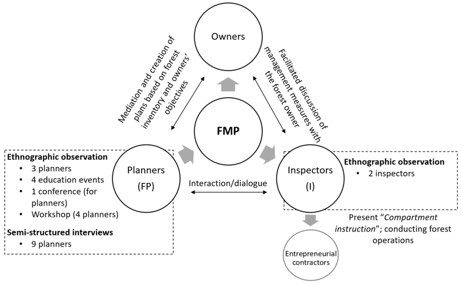
Figure 2. Study method and the key actors at Södra typically involved in the forest planning process.
For the interviews, forest planners were selected using maximal variation sampling (Flick 2023) to ensure diversity in geographic location, gender, and experience. Rather than pursuing comparative analysis, the sampling aimed to identify shared insights. Interviews were conducted remotely to accommodate participants across Södra’s territory (refer to Table 2). These data collection methods were conducted and analysed in Swedish. Quotations presented in this paper have been translated into English by the authors.
Table 2. Ethnographic observation of the planning process and semi-structured interviews with planners.
|
|
Actor/activity |
Occasions |
|
|
Ethnographic observation
|
Education/ training events |
4 |
|
|
FP1 |
9 |
||
|
I1 |
3 |
||
|
FP2 |
4 |
||
|
Planners’ conference |
2 |
||
|
FP3 |
1 |
||
|
I2 |
|
1 |
|
|
Workshop (4 planners) |
1 |
||
|
Semi-structured interviews
|
FP4 |
Duration 2:21:59 |
|
|
FP5 |
2:00:27 |
||
|
FP6 |
2:44:15 |
||
|
FP7 |
1:25:08 |
||
|
FP8 |
2:01:05 |
||
|
FP9 |
1:31:36 |
||
|
FP10 |
2:17:09 |
||
|
FP11 |
1:57:21 |
||
|
FP12 |
1:47:36 |
||
During ethnographic observation, the researcher assumed an interactionist role, also described as the “observer-as-participant” (Adler and Adler 2008), engaging with forest planners for brief periods while collecting data and conducting informal interactions. To minimise potential bias, planners who had been directly observed were not interviewed, as prior interaction could influence their response due to perceived expectations, social pressure, or a desire to align with the researcher (Ibid, Orb et al. 2001). Participants involved in ethnographic observations and interviews were informed about the overall purpose and exploratory nature of the study. Interview participants had additionally received information about the project during internal Södra meetings prior to participation. At the same time, the first author adopted an interpretative research stance, acknowledging that the interpretive process is shaped by the researcher’s subjective perceptions and positionality. Combining ethnographic observations, interviews, and documentary material facilitated data triangulation (Flyvbjerg 2006). Ethnographical observation provided a situated, contextual understanding, while interviews enabled participants to elaborate on issues observed in practice, confirm initial insights, and enhance the credibility of the findings from the observations (Tracy 2010, Flick 2023). Although a separate study would be needed to thoroughly examine the use of FMPs by inspectors, our interviews with planners have identified challenges across the knowledge-transfer chain among owners, planners, inspectors, and entrepreneurial contractors (see section 5.2.2). The ethnographic observations of two inspectors, along with insights from a planner with prior inspector experience, provided partial validation of the findings. Although the study primarily focuses on planners’ perceptions, subsequent discussions with Södra staff at a strategic level did not generate any objections to the findings.
Notes from ethnographic observations were compiled into an observation diary that was instrumental for elaborating the interview guide. The guide followed a constructivist logic, drawing on existing literature as well as themes that emerged during fieldwork. It consisted of four main parts, including planners’ profiles, purpose of FMP, planning procedures and support for planners at Södra (see Supplementary material B for further details). This structure enabled participants to articulate their priorities in their own terms while allowing the researcher to observe whether landscape-level considerations emerged spontaneously or only after prompting.
The data were analysed through thematic coding (Flick, 2023), and the analytical structure was guided by the themes in the interview guide. Table 3 provides an overview of a qualitative content analysis and illustrates how codes were grouped and categorised as relating primarily to back- and front-office planning activities.
Table 3. Categories and codes identified through thematic coding.
|
Themes |
Codes |
Category |
|
Forest planner’s identity
|
Planner’s status Planner’s initiative for changes |
Back-office |
|
FMP as a decision tool
|
Screening the owner’s objectives and information about the estate Information to meet diverse objectives and needs Capturing landscape values Usage of the plan throughout the planning chain |
Front-office
Back-office |
|
The planning procedure
|
Availability of instructions/procedures/templates Availability of harmonised data, tailored software, and documents to address a landscape scale Different planning pressures and routines Influences from the governance context |
Back-office |
|
Interaction with forest owners
|
Time allocation for interaction Defining owners’ objectives Variation of advice and topics |
Front-office |
|
Organisational structure and operative support |
Availability of technical infrastructure and support Actors’ roles & duties Organisational versus planners’ individual goals |
Back-office |
Thematic coding was chosen to enable a systematic identification of patterns and themes across both observational and interview data, supporting a nuanced understanding of the planning process. The same analytical structure is applied in the presentation of the results, where empirical findings are presented alongside observational data, interview material, and interpretive reflections, including normative considerations.
RESULTS: THE STATUS AND PROSPECTS FOR LANDSCAPE PERSPECTIVE IN FMPS
Landscape perspective
This section provides the context for the subsequent back- and front-office analyses by examining how planners conceptualise a landscape perspective in their daily work.
Interviewees were asked what a “landscape perspective” and “landscape values” mean to them, and whether such thinking could be incorporated into FMPs (Table 4). The responses, including remarks made throughout the interviews beyond these targeted questions, suggest that the landscape perspective most commonly remains implicit, informing participants' reasoning without being explicitly articulated. In a number of cases, discussion of this topic emerged only following targeted prompts from the interviewer.
The landscape perspective is, to varying degrees, integrated into planning practices depending on how individual planners reason about and make decisions regarding the allocation of land area (stands) to different forest goal classes. Practical expressions of landscape reasoning at the local landscape scale included the identification and creation of green corridors (e.g. FP6, FP8, FP10), the selection of set-asides for nature conservation purposes (e.g. FP5), and the recognition of historical landscape features where present (e.g. FP7, FP12). Key structural constraints included the 10-year planning horizon and the typical estate size of approximately 34 ha, both of which limit the scope for broader spatial reasoning (e.g. FP4, FP10).
Table 4 summarises planners’ perceptions of landscape perspective and their assessments of its practical feasibility within the FMP process. As the table illustrates, planners’ conceptualisations range from explicit spatial reasoning, linking set-asides, buffer zones, and green corridors, to more implicit, aesthetic, or intuitive notions of landscape care. Mostly, they reflect reasoning at the local landscape scale; a regional landscape scale, such as the documented forest biodiversity regions, was rarely taken into account.
According to the interviewed planners, the conditions for systematically including a landscape perspective within current planning frameworks are inadequate. The following sections examine the organisational, social, and technical factors underpinning this gap between landscape awareness and landscape practice, structured around back- and front-office respectively.
Table 4. Planners’ perceptions of landscape perspective and assessments of feasibility for incorporating landscape values into FMPs.
|
Forest planners |
Landscape perspective and values (Perceptions) |
Incorporating landscape perspectives IN FMP (Feasibility) |
|
FP4 |
I don’t think much about that in my everyday life as a planner. […] Look at what is nearby, what habitats surround the area, and what is important there. […] You work at the stand level, then the estate level, and consider what surrounds it; you might choose K [goal class] next to an area where natural values are present. […] Forest biodiversity regions indicate what you should prioritise, but it is also about the time perspective and your location - what you can influence now within the 10-year period that the plan covers. |
I guess you can, if you want to, but we operate at the estate level. The estate may be important from a landscape perspective, […] but I won’t prioritise taking the time to see what surrounds it within the next two kilometres. |
|
FP6 |
It’s that you might see that you get green corridors, you have coherent areas, perhaps create reinforcement [buffer] zones or a K goal in connection with a nature conservation area. […] In some cases, you can decide to have K, NS or No [goal classes] together so that they become a larger area of nature conservation purpose. […] But, most of the time I don’t think like this, that ”I’m going to add this so that we expand this way so that we create a corridor next to the nature conservation area”. I don’t do that. |
No. Or, well, I can check all the plans and the surrounding estates, but it is not very easy—I need to download them in the field app. I can think and operate in these terms, but the conditions for doing so are not very good right now, I would say. |
|
FP8 |
Tie together all types of nature conservation areas, both voluntary set-aside together with key-habitats, objects with nature values, and all target images for good environmental consideration that Swedish forest agency decided upon. Buffer zones, all types of habitats with high conservation values that we need to consider today in higher scale. The key is to create green corridors. |
No, I don’t think so. We don’t have the tools to work with this mindset. We can’t do that today, working from a landscape perspective. For me, it means we only have an opportunity to look at it. |
|
FP11 |
I mean, it is not at the landscape level, but landscape care is something I relate to more, it should look nice. Stands that are close to roads and buildings should be more aesthetic. […] There should be a greater distribution of broadleaves, pine, and mixed forests, and buffer zones should be preserved (general considerations). But, to be honest, I’m not really thinking at the landscape level. […] However, I do want to mention that we have these guidelines, forest biodiversity regions, and I do prioritise the tree species and habitats that are specified there. |
If we all follow the guidelines, e.g. buffer zones next to watercourses, and use the target images for good environmental consideration from the Swedish Forest Agency, then I think it has an impact at the landscape level. However, my goal setting is at the estate level. |
|
FP12 |
It is about preserving landscape values where they are present. […] It is somehow back in the head. It all depends on what is present and not, and what is typical for this specific landscape picture, it can also promote certain habitat that becomes more extraordinary. |
Yes, I think so… I’m not sure. You become familiar with what we have access to, and so on. Forest pearl’s is worth its weight in gold.
|
Södra’s back-office
Planners’ professional status and capacity
The findings demonstrate that planners’ operational performance is shaped not only by technical resources but by the social and organisational conditions that define their professional role within the organisation. Throughout the years (approximately 10 years), the staff capacity and the status of forest planning have undergone notable change, changes that planners themselves report initiating through sustained internal advocacy.
“We had to shout loudly that we are not satisfied, and now changes are taking place. But it will take time before it is in place, of course, for it to become good.” FP8
A significant recruitment round in 2023 expanded Södra's planning workforce from 14 to 35, enabling a shift from heavy reliance on externally contracted FMPs to greater internal planning capacity. Concurrently, the organisational structure was reconfigured from a single centralised planning unit into a decentralised system of four regional districts, each with one district coordinator planner. This restructuring can be expected to enable more robust quality control and more systematic implementation of desired changes, such as greater attention to clarifying owners’ needs, greater contact with regional inspectors, and more structured internal training of planners (e.g. FP5, FP7, FP9, FP10). Several planners emphasised the importance of improving communication with inspectors.
“The goal has been to have better contact with the inspectors and a closer dialogue with them both before and after [creating FMPs]. [...]. But some inspectors are very keen that there should be good contact, and some don't think it's necessary.” (FP6)
Despite these structural improvements, planners indicated that their claimed parity with inspectors (i.e. timber buyers) within the organisation was not reflected in practice, most notably in remuneration and professional recognition, as evidenced by persistent wage disparities (e.g. FP1, FP8).
“The message from the company is that we are very important and that the plan is the most important purchasing tool. […] However, it's not shown. It's evident both in salaries and as a general attitude in some places.” FP6
A recurring pattern is the recruitment of experienced planners into inspector roles while new, less experienced staff are brought into planning positions. This reflects a broader institutional perception of forest planning as an entry-level position, with the inspector role carrying greater professional prestige. One structural consequence of this pattern is the attrition of accumulated competence in forest management planning, as specialist knowledge built over time is not retained within the planning function (e.g. FP5, FP6, FP8).
At the same time, several planners articulated a strong positive identification with the planning role, citing its long-term planning horizon and nature conservation responsibilities as meaningful dimensions of their work (e.g. FP7, FP10). This suggests that reframing the professional status of planning, emphasising its distinct contribution to long-term forest stewardship, could help retain experienced practitioners. The loss of accumulated knowledge in species identification, nature conservation assessment, and long-term forest management, compounded by the pressure to complete plans within tight time constraints, directly limits planners’ capacity to integrate landscape-level considerations into their work.
Informants described a good planner as someone who is attentive to owners’ needs, acts as an independent and objective adviser, and possesses comprehensive knowledge of multiple forest values with long-term goals. This profile contrasts with that of an inspector, whose role is oriented towards a shorter-term timber procurement and stand-level decisions (e.g. Curtis et al., 2023). This mismatch potentially undermines the perceived value of planning and the quality of management decisions:
“The forest planner gets to test the pulse of the forest owner; they can see the estate or the whole picture compared to the inspector who works at the stand-level.” I2.
“FMP is the foundation of the entire job of a forest inspector. […] it [the advice] also becomes credible if both the planner and the inspector say the same thing.” FP8
Organisational routines were also identified as a constraint on planners’ ability to centre on owner objectives. One planner drew attention to a tension embedded in the standard field instruction template:
“Why does the so called “Field-instruction” template tell that we should follow Södra’s suggested management measures and choose those in the first instance, and not the suggested measures from the owners? But the plan is for the owners!” FP1
This example illustrates how procedural defaults can functionally override the stated purpose of FMP as an owner-centred planning tool, irrespective of individual planners’ intentions.
Nature conservation responsibilities were viewed by many planners not as a burden but as a meaningful and increasingly important dimension of professional practice (e.g. FP5, FP6, FP7, FP8, FP9, FP10, FP12). Some anticipated that nature conservation would eventually constitute the primary focus of planning work. Planners were also aware of longer-term developments in the sector, including an emerging dynamic FMP model with greater reliance on remote sensing and reduced dependence on field inventory, a prospect that some viewed with apprehension regarding the future scope of their professional role (Planner's conference). However, as discussed in the following section, the technical infrastructure and support functions available to planners for this purpose remain insufficient.
Technical infrastructure and support functions at the back-office
The previous section addressed the organisational and social conditions shaping planners’ professional practice. This section turns to the technical infrastructure and support functions that underpin the planning process, focusing on three interrelated challenges: the fragmentation of decision-support tools across the planning chain; gaps in nature conservation support; and the absence of landscape-level data and functionality. Together, these constraints help explain why landscape awareness, as documented in section 5.1, rarely translates into landscape practice.
A structural limitation across the planning chain concerns the use of different and poorly integrated decision-support tools by planners and inspectors, respectively. Planners work within Södra’s forest management planning system (s-plan), while inspectors rely primarily on a separate Field app for operational decision-making (See supplementary A for further information). Critical information produced during planning, including owner objectives, nature conservation designations, and the rationale behind proposed management measures, is not systematically transferred between these tools.
“The problem is that not all information is available to us [inspectors]. We lack information, i.e. comments regarding forest management methods. [...] It would have been nice to read more about what the planners were thinking, i.e., planting broadleaves after harvesting spruce, because, at the moment, the plan [for a specific estate] goes against certification.” I1
“What we don't have is the property comment, where the forest owner's goals are written. It doesn't come with the Field app. Nor do we have blue classifications and watercourses and point objects [cultural heritage or species/habitats].” FP8
Within Södra’s back-office, the Digital Development function/unit has been working towards greater integration of these systems, with the stated aim of enabling more consistent knowledge transfer across planners, inspectors, forest owners, and contractors. However, at the time of data collection, this integration remained incomplete, and the informational gap between planning and inspection functions persisted. Moreover, the ongoing transformation of digital systems did not attempt to resolve the structural limitations of existing data infrastructure, which continued to restrict landscape-level planning and cross-estate coordination.
Planners identified gaps in supporting material available for species identification and nature conservation decision-making. While some reported being able to draw on expertise within Södra’s ecological function/unit for guidance (e.g. FP1, FP6, FP7, FP8, workshop), this support was inconsistently available and compounded by conflicting external interests.
“Different organisations say different [priorities about the species requirement], creating uncertainty. […] Södra says to cut down because we don't find any species, and the County Administrative Board thinks it could become a nature reserve. [...] It is complicated and demanding.” FP4
A guiding document on Forest biodiversity regions, prepared approximately a decade ago by Södra in collaboration with external ecologists, identifies key habitats of regional significance to assist planners in selecting set-aside areas on Södra members’ estates (Aulén et al. 2014). However, planners did not refer to this document as a supportive tool without additional prompts from the interviewer. While some mentioned that incorporating the guidelines about nature conservation in certain regions feels intuitive during their planning process and choice of set-asides, it is difficult to make the information explicit in the FMP. For example, some planners requested better estimation of suitable forest habitats to be set aside and what management efforts are required. Thus, by Södra’s default, similar habitats or areas are chosen as set-aside options on the entire estate, without adequate reference to the regional ecological context. This approach risks overlooking ecologically or culturally features and may reduce the coherence of conservation efforts at a landscape scale.
Although a landscape perspective is referenced in relevant standards and frameworks, including the FSC standard (FSC 2020) and Södra's Forest Biodiversity Regions (Aulén et al. 2014), it is largely absent from operational planning practice, in part due to technical discontinuities: the absence of harmonised spatial data and purpose-built software oriented towards landscape-scale analysis. “Mainstream” concepts and templates remain oriented towards traditional rotational forestry practices, with landscape considerations neither systematically prompted nor readily accommodated (Table 5).
Several planners emphasised the importance of considering neighbouring estates and existing voluntary set-asides in surrounding areas, but noted that this was only feasible when neighbouring owners were Södra members with an existing FMP (e.g. FP4, FP6, FP8, FP10). Even where such information was available in principle, it did not consistently inform decisions at the individual estate level (e.g. FP8, FP11), and there is currently no automated mechanism for planners to view adjacent set-asides. Planners request better-tailored tools, i.e. species indicators, map services and geographic information, and guidelines from authorities:
“We need more tools that provide practical measures; better initiatives that would address a landscape perspective” (Individual comment, workshop).
Planners expressed concern that current technological solutions lack credibility and are customised primarily for conventional rotational forestry. Several existing datasets and official resources (e.g. Key habitat inventory[7] and Forest pearls[8]) are no longer being actively updated, reducing their practical utility. Södra is moving towards a dynamic FMP with greater remote sensing integration and reduced reliance on field inventory, with the stated aim of enabling more continuous updating of forest management activities and more conscious management decisions. Planners indicated that if remote sensing could be made sufficiently reliable for standard forest variables, it would free up field time for ecological and social value assessment, a reorientation of effort they considered both necessary and overdue.
“A lot is happening on the technology side [...]. However, if we can make it work so that we can focus more on what is really important, i.e. nature conservation, prioritise it in the right way, have time to spend on it. I mean, how much volume there is in the spruce plantation is a worldly thing, and if a satellite or an aeroplane [remote sensing] can tell me about it and I don’t have to measure it, then I’m grateful. But right now, we can’t trust the tools; sometimes it’s right, and sometimes it’s not right. [...] In any case, the production forest is, after all, quite boring for a planner.” FP6
Finally, planners identified the need for new goal- and harvest classifications capable of accommodating and distinguishing between alternative silvicultural measures, such as selective/group thinning. Under the current FMP system, planners may propose alternative management options but cannot document the rationale, implementation approach, or long-term implications of those choices, limiting the informational value of the FMP for subsequent management decision-making.
Table 5. The forest management planning process with identified challenges for integrating forest owners’ objectives and a landscape perspective in FMPs.
|
Planning phases |
Task |
Activity |
Challenges |
|
Preparatory phase |
Contact with forest owners
|
Defining owners’ objectives, interests, and ambitions |
Difficult to define owners’ objectives and ambitions. A standard questionnaire can be sent out, but it is focused on traditional rotational forestry.
Variation of advice due to time, routines, and knowledge. |
|
Preparatory data processing
|
Summarising characteristics of the estate |
Lack of tailored shapes and maps that consider valuable landscape data outside the estate, and of updated sources of species and habitat information.
Information on Forest biodiversity regions can assist in planning, but lacks harmonisation with the FMP. |
|
|
Dividing stands |
Interpretation of orthophotos is not accurate many times, due to differences in reality. |
||
|
Fieldwork
|
Field/or remote sensing inventory
|
Collecting forest data in situ Assessing remote sensing data |
Nature value assessment template for choosing set-asides (NS-NO) not appropriately used. By default, similar habitats/areas are chosen across the estate, with no consideration of a landscape perspective.
Forest data inventory versus species requirements: remote sensing data works well for homogenous forests only.
Challenging with red-listed species (umbrella species, etc.), knowledge, and time limit for species inventory. |
|
The wrap-up phase |
Finalisation of the plan
|
Transferring the plan from the field computer to the computer
|
Summaries of the green comments and proposals for measures are of varying quality.
No additional information about the chosen management measures, the long-term goal and ways to achieve it.
Difficult to aim for alternative forest methods with todays’ goal and harvest classifications. |
|
Approval of the plan
|
The plan is often accepted immediately without discussion between the planner and the owner. Two challenges with this: (a) a missed opportunity to anchor FMP proposals operationally and strategically with the owner, (b) inspectors have other objectives and use other information systems as decision support. |
Södra’s front-office
Addressing the owner’s needs
This section examines front-office activities, focusing on planners’ interactions with forest owners. The majority of planners emphasised that the FMP is intended to support forest owners’ decision-making, yet adequately addressing owners’ objectives in practice remains challenging.
Planners have observed that most owners are either uncertain about or unable to articulate their goals. Responses from the interviews indicated variation in how planners approached this challenge: some recognised the need to adopt more tailored interaction strategies, asking probing questions (e.g. FP2, FP5, FP6) and drawing on both previous FMPs (e.g. FP7, FP12) and the current condition of the estate to build a comprehensive understanding of owner intent. In many cases, if owners did not articulate clear objectives, planners are required to infer them, a task for which current planning guidelines offer limited practical guidance.
Most owner interaction takes place by email or phone during the preparatory phase, with some planners following up during or after fieldwork. Less experienced planners typically hand out a standardised questionnaire to elicit owners’ key preferences. As one planner noted: “The plan is created for the owner’s objectives, but the goals are usually decided in the field, specifying measures and purposes” (FP1). The time planners spend with an owner varies considerably, from 45 minutes to three hours, all depending on the owners’ preferences of interaction of owners and the work routines of individual planners.
The most discussed topics included (i) the political and social debate about forestry practices (dos and don’ts), (ii) timber volumes (in economic terms), (iii) risks such as windthrows or bark beetle, not specifically discussing climate change per se, (iv) the selection of set-asides stands, and (v) the history of the estate. Ecological and social values were typically addressed only to the degree required by voluntary set-asides[9] (estimation of 5% of estate area), with broader engagement dependent on the owner’s expressed interest. Where applicable, nature conservation premiums were cited by some planners as a useful instrument for negotiating a higher proportion of set-asides (e.g. FP5, FP7).
“It [premium] has helped a lot. It has almost gone a little too much sometimes because some [owners] want to create values where there are no values.” FP10, and “it must be existing and potential values to get this premium.” FP9
The selection of set-asides stands was generally described as a planner-led process, negotiated with owners to varying degrees. In some cases, owners sought to designate areas of low timber productivity as set-asides, while planners resisted this where it conflicted with their assessment of ecological value (e.g. FP2, FP8). Two planners (FP8, FP9) highlighted the value of a more pedagogical approach to knowledge exchange, bringing owners into the field to explain the reasoning behind conservation recommendations and, where appropriate, using the nature value assessment template[10] as an explanatory tool. Additional support from the ecological unit/function or district plan coordinator was available to planners when complex decisions required further clarification.
Planners and owners, in many cases, also interact when the FMP is compiled. However, according to the informants (FP8, FP11), the inspector often presents the finalised FMP, and that decision is based on the forest owner’s choices. Some planners suggested that they should discuss the recommendations in the plan (e.g. FP6). Some even expressed frustration because, despite a good relationship with owners and emerging novel ideas, their efforts become useless if the inspector fails to consider the information and suggestions in the FMP (FP2, FP5). Both planners and inspectors aim to build a working relationship with the forest owner, but the degree and content of advice depend on planners’ and inspectors’ individual duties. The FMP thus serves as a repository of the owner's wishes and long-term goals, which is particularly valuable given the frequency with which inspectors change, as one planner noted:
“If you have a special request regarding certain specific stands, then it's very clearly stated in the FMP, provided that the planner has been responsive and included it the way we're supposed to” (FP7).
Knowledge transfer through FMPs
Judging FMP as a decision-support tool for owners the interviewed planners generally agree that the current FMP does not function as an effective knowledge base for enhancing a landscape perspective, and multiple interviewees expressed doubt regarding the FMP’s ability to respond to owners’ needs and objectives.
“It's somewhat incorrect to provide to owners identical FMPs. We have a wide variety of owners who need and request different types of information depending on their interests.” (Group communication, Workshop)
Most planners regard the current FMP as a static product that is difficult to interpret and adopt; similar concerns were voiced by forest owners in Södra’s recent survey of its members (Internal source from Södra’s staff). The majority of the interviewed planners explained that the FMP’s purpose is to serve as a planning tool for the owners, but with a high focus on timber volume and production, whereas integrating a landscape perspective or aligning with different owners’ objectives within the FMP is limited. Planners expressed the need for alternative plans suited to owners’ objectives and ambitions, for enhanced visualisations and improved data to demonstrate multiple forest values.
In some cases, small adjustments can substantially enhance ecological and social values. Along with the chosen goal classification focusing on nature consideration, so-called green comments are an important supplement of qualitative information, where the focus is to describe a given stand (habitat), information on the objectives for the stand’s development, and the measures required to meet the objectives. Valuable identified objects can be mentioned in these green comments, but they do not necessarily reflect a landscape scale. Some planners say it is in their minds, but they do not explain characteristic elements or attributes from a landscape perspective.
Some planners advocate registering or highlighting additional values in the FMP. One planner came up with a potential solution to connect important values or habitats with description codes (e.g. FP8), and another planner suggested general figures as visualisations for ecological and social values, e.g. different valuable habitats/biotopes, species richness, buffer zones, green corridors, and patches for general or additional nature consideration (e.g. FP2). The first planner emphasised that such values should not be treated as isolated areas but integrated within production stands, while still being made visible in the plan:
“We don’t want buffer zones and demanding biotopes as separate stands. We want them within the production areas so that we can leave the general consideration there. However, it’s important to register them, to have them on the map: to display them in some way.” FP8
The planner further argued that visualising these elements at a landscape scale could reveal a connectivity that is not immediately apparent when viewing stands in the FMP: “If we added all these consideration areas we work with, then we’d have a completely different situation… to show: here’s how we’ve connected everything” (FP8). These suggestions could contribute to a more visually informative map highlighting important habitats, while also appealing to owners who appreciate values other than timber production, as well as those who prefer more visual information (e.g. Pynönnen 2021). In addition, they enable scaling from individual stands to the estate and landscape level, while demonstrating that certain areas exhibit a higher degree of spatial continuity.
DISCUSSION
Challenges in owner-planner interactions
There is a growing interest among European forest owners to diversify forest management (Weiss et al. 2019, Lidestav and Westin 2023), e.g. by raising species diversity from natural regeneration or testing alternatives to currently prevailing rotational forestry. The growing concern for climate-related risks (i.e., windthrow, drought, disease) among owners (Olofsson & Jakobsson, 2024), combined with aspirations for greater forest diversity, creates a propitious opening for more explicit integration of a landscape perspective (Mazziotta et al., 2026; Gustafson et al., 2020).
The informants broadly agreed that planners are expected to maintain an objective and independent advisory role; yet in practice, identifying forest owners’ goals frequently proves challenging. Revised procedural templates (e.g. field instructions and owner questionnaire) could better capture the diversity of owners’ needs and facilitate more systematic incorporation into FMP. Of equal importance is investment in planners’ interpersonal and communicative competencies for building relationships and co-constructing knowledge with owners. There is clearly room for Södra to develop these capabilities further, for instance by adopting coach roles (Dockés et al. 2019) that could both enhance planners’ responsiveness to owners’ often implicit needs and encourage owners to consider forest values that extend beyond their own estate boundaries (e.g. Mayer 2019), a reasoning central to the local and regional landscape perspective. This need becomes especially salient in light of ongoing changes in forest owner characteristics, as forest management becomes increasingly complex and technically demanding, while owners are increasingly non-resident and reliant on external advice (Lawrence et al. 2020).
The empirical data also revealed growing uncertainty about the future role of planners, particularly in light of proposals to replace today’s static and analogue FMPs with dynamic digital alternatives enabling real-time updates (e.g. Södra 2025). The ongoing digital transformation presents forest management organisations with a critical juncture for reorienting planning practice. It is essential, however, that these technological advancements do not result in commodification or depersonalisation of forest management planning by shifting FMPs toward increasingly automated, data-driven outputs. A growing reliance on remote sensing, predictive modelling, and digital planning systems risks privileging quantifiable forest variables (cf. Ulvdal et al. 2023; 2025, Baskent et al. 2024) over owners’ values and objectives, thereby reducing FMPs to automated data summaries that inadequately capture ecological, social, and personal dimensions of forest ownership. At the same time, planners may face increasing difficulties in translating complex digital outputs into guidance genuinely responsive to owners’ needs and objectives (Király et al. 2023). Forest owner associations and forest companies are arguably best positioned to govern this transition, as they hold institutional authority over planning standards and the client relationship with owners (cf. Thorning 2024). This transition calls for investment in reformed forest education curricula (Mermet and Farcy 2011) that, alongside technical knowledge, develop planners’ skills in communication and knowledge co-creation with owners (Wallin and Brukas 2024).
Integrating landscape perspective
The interviewed planners communicated a strong sense of initiative and possess a wealth of ideas for improving Södra’s practices. Södra’s back-office needs to facilitate the front-office operations through better-tailored technical tools, educational resources, and procedural templates. Södra, like many forest organisations in Sweden and elsewhere, faces pressures to adapt its services to changing member expectations, societal demands, and forest governance context (e.g. Pezdevšek Malovrh et al. 2024, Thorning 2024). Södra has lately engaged heavily in technical development, e.g. in an effort to move away from static FMPs to more dynamic planning. However, the aspirations to include landscape perspective are not clearly articulated, although more targeted measures appear to be both feasible and necessary.
First, retaining experienced planners within the planning function represents a critical and currently unaddressed challenge. As the results indicate, the recurring pattern of recruiting experienced planners into inspector roles, reinforced by planning being treated as an entry-level position, risks depleting the accumulated landscape knowledge. This includes awareness of land-use history, past disturbances, and other local landscape particularities essential for operating from a landscape perspective (e.g. Bakx et al. 2024). Södra should therefore consider how to strengthen planners’ professional status and career pathways, so that specialist competence is retained and developed over time rather than routinely transferred out of the planning branch.
Second, the planner could facilitate or recommend “cooperative management” of forest landscapes among owners, including various formal mechanisms to enhance collaboration and promote knowledge exchange (cf. Fischer et al., 2019; Mayer, 2019). Such approaches could, in turn, address larger forest habitat networks across ownership boundaries (Angelstam et al. 2023), for example, by comparing FMPs to identify which forest characteristics are missing or present from a landscape perspective. This kind of cross-estate coordination represents a step toward a local landscape perspective, rather than a regional one, given that collaboration among a few owners typically covers only a limited area. However, it is essential to acknowledge that these measures can be time-consuming, as planners already work within tight time constraints to complete plans, and not all neighbours may be Södra members. An open question is whether incentives, akin to a nature conservation premium, could further encourage such cooperative activities, or can somehow be implemented as an action connected to today’s Södra group certification scheme and FSC requirements for “adapted forest methods”[11], if applied on a smaller scale rather than across the whole Södra.
Third, the currently underutilised Södra’s Forest biodiversity regions (Aulén et al. 2014), can offer valuable guidance for integrating regional landscape attributes into planning at the stand- and estate-levels. The limited integration of this information into FMPs does not stem from a lack of awareness or capacity among planners but rather is a structural constraint in translating planners’ implicit knowledge into explicit outputs. Rather than focusing solely on goal- and harvest classifications within the estate, as is typical in operational forest planning, the maps in FMPs could instead highlight broader landscape patterns, i.e. incorporating the localisation of valuable habitats and strategies for connecting them at a landscape scale (e.g. Messier et al. 2019), and include visual representations of ecological and social values that support owner understanding and decision-making (cf. Pynnönen et al. 2021). Planners request better-tailored and updated map layers to zoom out to the surrounding local landscape, and where relevant, to regional landscape patterns such as the distribution of valuable habitats across larger areas. This would align with what Bettinger et al. (2017, Ch. 1) label as “landscape plans” with more explicit consideration of multiple spatial and temporal dimensions. If planners can visualise these values in the surrounding area, their capacity to propose management strategies that enhance values beyond a single estate would be substantially improved.
Fourth, across Europe, countries tend to adapt subsidy programmes to suit their national priorities, often focusing on afforestation or improving forest productivity (Haeler et al. 2023, Nebasifu et al. 2025). Economic incentives specifically aimed at promoting voluntary nature conservation or often quite limited. The absence of state incentives and the limited engagement of dominant private actors pose a significant barrier to advancing landscape planning. However, the recently introduced nature conservation premiums at Södra (see Section 3) represent a valuable instrument that planners can use to motivate owners to enhance conservation measures and potentially incorporate landscape values. These premiums reflect Södra’s commitment to advancing nature values within members’ forests, yet their effective implementation rests largely with individual forest planners. Alongside improved communication strategies with owners, planners require enhanced technical support from the back-office in order to realise the full potential of this instrument, including its application to landscape connectivity.
FMP as a policy instrument
The content and format of FMPs have remained largely unchanged for decades, not only in Sweden but also internationally. Our findings align with evidence from a range of national contexts, collectively pointing to structural shortcomings rather than context-specific factors as the primary source of FMPs’ limited relevance and usability. FMPs frequently fail to adequately reflect owners’ objectives (e.g. Bashir et al. 2024), insufficiently represent forest dynamics needed to project future forest conditions (e.g. Baskent 2024), or employ presentation formats that are poorly suited to practice-oriented decision-making (e.g. Pynnönen et al. 2019). These converging observations reinforce the case for moving towards more adaptive, forward-looking, and user-centred FMP design.
Recent EU policy debates have explored the possibility of making FMPs a legally binding instrument to steer forest management more decisively towards resilience (European Commission 2023). Under such a framework, FMPs would take on a more normative character even in laissez-faire countries like Sweden. Whatever the future outcomes at the EU level, in its recent rapport the Swedish Forest Agency articulated clear aspirations to develop a radically new model (approach) to forest management planning that would, among other things: (i) enable more flexible planning across different time horizons and geographical scales – including the local and regional landscape levels identified in this study; (ii) pay greater attention to social values and risks, beyond the current dual focus on forest production and nature values; (iii) place owners’ needs at the centre, guiding them towards the realisation of long-term objectives; and (iv) provide stronger support for alternative silvicultural systems such as continuous cover forestry (SFA 2025a). Realising these ambitions will be challenging, given that the agency has withdrawn from operational forest planning. Nevertheless, the report signals a supportive policy environment for aims such as better accommodation of owners’ needs and the integration of a landscape perspective. This implies a need for a nationwide infrastructure for regular updating of harmonised forest data, potentially including landscape-scale attributes and visualisations (Lannér et al. 2022). However, improved data availability alone will not be sufficient. Certain key concepts will also require revision to better accommodate practical landscape-based approaches. For example, while the Swedish national FSC standard acknowledges the importance of a landscape perspective, it lacks specific criteria and practical guidance for its implementation. A concrete initial step would be to develop new goal- and harvest classes that better reflect the diversity of owners’ objectives and support more diversified forest management, including landscape-scale considerations.
CONCLUSION
With the forest owner association Södra as the case, this study identified the challenges with incorporating a landscape perspective and accommodating the multiple needs of forest owners in forest management planning. Over the past decade, Södra’s front-office routines have improved, notably through greater communication between planners and owners. Planners regard themselves as objective advisors, and some express genuine appreciation for the challenge of moving beyond traditionally production-oriented forestry. While there is evident scope for strengthening planner-owner interactions in the front-office, the more fundamental limitations are found in the back-office, where the capacity to address landscape-scale considerations is constrained by the absence of harmonised data and tailored planning software, and outdated procedural templates. Consequently, both the planning process and the resulting FMP tend to remain focused at the stand level, insufficiently attending to broader ecological and social values and failing to adequately reflect the diversity of owners’ objectives. Some of these challenges transcend organisational capacity, and implicate wider societal and policy-related conditions, including the need for harmonised data sources and updated concepts (e.g. harvest- and goal classes) suited to operating at the landscape scale. Our findings point to a need for state support and incentives to enable a more coordinated and effective approach to landscape-oriented planning. Finally, this study has concentrated on the integration of a landscape perspective within the forest planning process and in the FMP as its principal output. The subsequent use of FMPs by forest owners, timber buyers (inspectors) and other actors constitutes an important direction for future research.
CONFLICTS OF INTEREST
The authors declare that they have no known competing financial interests or personal relationships that could have appeared to influence the work reported in this paper.
ACKNOWLEDGEMENTS
We would like to express our gratitude to Södra, those who facilitated our participation in fieldwork by accompanying forest actors through ethnographic observation, and the forest planners who participated in the interviews to make it possible to study the practical challenges for meeting the multidimensional needs of forest owners and integrating a landscape perspective in forest management planning.
FUNDING
This work was supported by the Formas project Co-creator under Grant number 2022-02082.
REFERENCES
Adler P, Adler P. In: Denzin NK, editor. 2008. Collecting and interpreting qualitative materials.
Angelstam P, Bush T, Manton M. 2023. Challenges and solutions for forest biodiversity conservation in Sweden: assessment of policy, implementation outputs, and consequences. Land. 12(5):1098. https://doi.org/10.3390/land12051098
Antrop M, Van Eetvelde V. 2017. Landscape perspectives. Berlin (DE): Springer. https://doi.org/10.1007/978-94-024-1183-6
Appelbaum SH. 1997. Socio-technical systems theory: an intervention strategy for organizational development. Manag Decis. 35(6):452-463. https://doi.org/10.1108/00251749710173823
Arts B, Behagel J, Turnhout E, De Koning J, Van Bommel S. 2014. A practice-based approach to forest governance. For Policy Econ. 49:4-11. https://doi.org/10.1016/j.forpol.2014.04.001
Aulén G, Gustafsson L, Kruys N. 2014. Skogliga naturvärdesregioner för södra Sverige - andra upplagan. Växjö (SE): Södra.
Bakx TR, Akselsson C, Trubins R. 2024. Exploring the diversity of non-industrial private forest properties in southern Sweden. Scand J For Res. 39(6):298-309. https://doi.org/10.1080/02827581.2024.2398235
Bashir A, Sjølie HK, Solberg B. 2024. Forest management plan pathways for non-industrial private forest owners in Norway: from acquisition to implementation. Eur J For Res. 143(5):1461-1475. https://doi.org/10.1007/s10342-024-01705-w
Baskent EZ. 2024. A thorough assessment of various forest management planning initiatives and development of improvement strategies towards an ecosystem-based planning. Environ Dev. 50:101006. https://doi.org/10.1016/j.envdev.2024.101006
Baskent EZ, Borges JG, Kašpar J. 2024. An updated review of spatial forest planning: approaches, techniques, challenges, and future directions. Curr For Rep. 10(5):299-321. https://doi.org/10.1007/s40725-024-00222-8
Beland Lindahl K, Westholm E, Kraxner F, Lidestav G. 2017. The Swedish forestry model: more of everything? For Policy Econ. 77:44-55. https://doi.org/10.1016/j.forpol.2015.10.012
Bettinger P, Boston K, Siry J, Grebner DL. 2017. Forest management and planning. 2nd ed. London (UK): Academic Press.
Brockerhoff EG, Barbaro L, Castagneyrol B, Forrester DI, Gardiner B, González-Olabarria JR, et al. 2017. Forest biodiversity, ecosystem functioning and the provision of ecosystem services. Biodivers Conserv. 26(13):3005-3035. https://doi.org/10.1007/s10531-017-1453-2
Brukas V, Sallnäs O. 2012. Forest management plan as a policy instrument: carrot, stick or sermon? Land Use Policy. 29(3):605-613. https://doi.org/10.1016/j.landusepol.2011.10.003
Brukas V, Felton A, Lindbladh M, Sallnäs O. 2013. Linking forest management, policy and biodiversity indicators - a comparison of Lithuania and southern Sweden. For Ecol Manag. 291:181-189. https://doi.org/10.1016/j.foreco.2012.11.034
Buchy M, Hoverman S. 2000. Understanding public participation in forest planning: a review. For Policy Econ. 1(1):15-25. https://doi.org/10.1016/S1389-9341(00)00006-X
Council of Europe. 2000. European Landscape Convention (ETS No. 176). Florence (IT).
Curtis K, Guillén LA, Brukas V. 2023. Creating the landscape, one stand at a time: the dual roles of timber buyers in the nested domains of Swedish forestry. For Policy Econ. 147:102884. https://doi.org/10.1016/j.forpol.2022.102884
Denzin NK, Lincoln YS, editors. 2011. The SAGE handbook of qualitative research. Los Angeles (CA): SAGE.
Dockès AC, Chauvat S, Correa P, Turlot A, Nettle R. 2019. Advice and advisory roles about work on farms: a review. Agron Sustain Dev. 39(1):2. https://doi.org/10.1007/s13593-018-0547-x
Elbakidze M, Angelstam P, Dawson L, Shushkova A, Naumov V, Rendenieks Z, et al. 2018. Towards functional green infrastructure in the Baltic Sea region. Ecosyst Serv For Landsc. p. 57-87.
https://doi.org/10.1007/978-3-319-74515-2_4
European Commission. 2023. Proposal for a regulation on a monitoring framework for resilient European forests. COM(2023) 728 final. Brussels (BE).
Felton A, Löfroth T, Angelstam P, Gustafsson L, Hjältén J, Felton AM, et al. 2020. Keeping pace with forestry: multi-scale conservation in a changing production forest matrix. Ambio. 49:1050-1064. https://doi.org/10.1007/s13280-019-01248-0
Fischer AP. 2018. Forest landscapes as social-ecological systems and implications for management. Landsc Urban Plan. 177:138-147. https://doi.org/10.1016/j.landurbplan.2018.05.001
Fischer AP, Klooster A, Cirhigiri L. 2019. Cross-boundary cooperation for landscape management. Landsc Urban Plan. 188:151-162. https://doi.org/10.1016/j.landurbplan.2018.02.004
Forest Europe. 2020. State of Europe's forests 2020.
Flick U. 2023. An introduction to qualitative research. 7th ed. Los Angeles (CA): SAGE. https://doi.org/10.4135/9781036231712
Flyvbjerg B. 2006. Five misunderstandings about case-study research. Qual Inq. 12(2):219-245. https://doi.org/10.1177/1077800405284363
Forest Stewardship Council Sweden. 2020. The FSC national forest stewardship standard of Sweden. Available from: https://se.fsc.org/se-sv/regler/skogsbruksstandard
Guillén LA, Wallin I, Brukas V. 2015. Social capital in small-scale forestry: a local case study in southern Sweden. For Policy Econ. 53:21-28. https://doi.org/10.1016/j.forpol.2014.12.006
Guillén LA, Garfield D, Brukas V. 2026. A map is more than a polygon: contesting green infrastructure in forested landscapes in Sweden. Environ Manage. 76(4):123. https://doi.org/10.1007/s00267-026-02416-1
Gustafson EJ, Kern CC, Miranda BR, Sturtevant BR, Bronson DR, Kabrick JM. 2020. Climate adaptive silviculture strategies. For Ecol Manag. 470:118208. https://doi.org/10.1016/j.foreco.2020.118208
Haeler E, Bolte A, Buchacher R, Hänninen H, Jandl R, Juutinen A, et al. 2023. Forest subsidy distribution in five European countries. For Policy Econ. 146:102882. https://doi.org/10.1016/j.forpol.2022.102882
Johnsson F, Beery T. 2023. Outdoor recreation and the private forest owner. Front Conserv Sci. 3:1058557. https://doi.org/10.3389/fcosc.2022.1058557
Karlsson A, Guillén LA, Brukas V. 2024. Regional forest green infrastructure planning and collaborative governance. Environ Sci Policy. 160:103840. https://doi.org/10.1016/j.envsci.2024.103840
Király G, Vágó S, Bull E, Cruyssen LVD, Arbour T, Spanoghe P, Van Dijk L. 2023. Information behaviour of farmers, foresters, and advisors. Stud Agric Econ. 125(1):1-12.
Kittredge DB. 2005. The cooperation of private forest owners on scales larger than one individual property. For Policy Econ. 7(4):671-688. https://doi.org/10.1016/j.forpol.2003.12.004
Labarthe P, Laurent C. 2013. Privatization of agricultural extension services in the EU. Food Policy. 38:240-252. https://doi.org/10.1016/j.foodpol.2012.10.005
Lannér J, Brunet J, Curtis K, Grönlund Ö. 2022. Landskapsanpassad naturvårdande skötsel och lämna hänsyn. Skogsstyrelsen.
Lawrence A, Deuffic P, Hujala T, Nichiforel L, Feliciano D, Jodlowski K, et al. 2020. Extension, advice and knowledge systems for private forestry. Land Use Policy. 94:104522. https://doi.org/10.1016/j.landusepol.2020.104522
Li JH, Huang QB, Lin L. 2014. Social capital and knowledge transfer in new service development. Interdiscip J Inf Knowl Manag. 9:153-174. https://doi.org/10.28945/2073
Lidestav G, Westin K. 2023. The impact of Swedish forest owners' values and objectives. Small-Scale For. 22(3):435-456. https://doi.org/10.1007/s11842-022-09538-4
Mach M, Sabol T, Paralic J. 2006. Integration of eGov services: back-office versus front-office integration. In: Proc ESWC Workshop. p. 48-52.
Mayer AL. 2019. Family forest owners and landscape-scale interactions: a review. Landsc Urban Plan. 188:4-18. https://doi.org/10.1016/j.landurbplan.2018.10.017
Mazziotta A, Eyvindson K, Albrich K, Honkaniemi J, Romeiro JMN, Suvanto S, Kangas A. 2026. Management approaches in decision support systems to mitigate risks of natural disturbances. Ecol Model. 516:111565. https://doi.org/10.1016/j.ecolmodel.2026.111565
Mermet L, Farcy C. 2011. Contexts and concepts of forest planning. For Policy Econ. 13(5):361-365. https://doi.org/10.1016/j.forpol.2011.03.006
Messier C, Bauhus J, Doyon F, Maure F, Sousa-Silva R, Nolet P, et al. 2019. Functional complex network approach to forest resilience. For Ecosyst. 6:1-16. https://doi.org/10.1186/s40663-019-0166-2
Michanek G, Bostedt G, Ekvall H, Forsberg M, Hof AR, De Jong J, et al. 2018. Landscape planning for biodiversity conservation. Forests. 9(9):523. https://doi.org/10.3390/f9090523
Nebasifu AA, D'Amato D, Ekström H, Pietarinen N, Fridén A, Harrinkari T, et al. 2025. Comparing Nordic forest governance. For Policy Econ. 170:103368. https://doi.org/10.1016/j.forpol.2024.103368
Nichiforel L, Keary K, Deuffic P, Weiss G, Thorsen BJ, Winkel G, et al. 2018. How private are Europe's private forests? Land Use Policy. 76:535-552. https://doi.org/10.1016/j.landusepol.2018.02.034
Nordström EM, Eriksson LO, Öhman K. 2010. Integrating MCDA in participatory forest planning. For Policy Econ. 12(8):562-574. https://doi.org/10.1016/j.forpol.2010.07.006
Olofsson E, Jakobsson R. 2024. Private forest owners' climate adaptation measures. Scand J For Res. 39(5):263-276. https://doi.org/10.1080/02827581.2024.2380685
Paltto H, Nordén B, Götmark F, Franc N. 2006. Landscape context effects on species density. Biol Conserv. 133(4):442-454. https://doi.org/10.1016/j.biocon.2006.07.006
Pezdevšek Malovrh Š, Avdibegović M, Morelli S, Paletto A. 2024. Evolution of private forest owners' cooperation. Small-Scale For. 23(3):393-421. https://doi.org/10.1007/s11842-024-09569-z
Pynnönen S, Haltia E, Hujala T. 2021. Digital forest information platform as service innovation. For Policy Econ. 125:102404. https://doi.org/10.1016/j.forpol.2021.102404
Pynnönen S. 2020. Knowledge use in the management of privately owned forests. Dissertationes For. 289. https://doi.org/10.14214/df.289
Sandström E, Sahlström E. 2021. Biosphere reserves through collaborative governance.
Swedish Forest Agency. 2020. Handbok - Nyckelbiotopsinventering.
Swedish Forest Agency. 2021. Åtgärder i skogsbruket 2020.
Swedish Forest Agency. 2024a. Fastighets- och ägarstatistik i skogsbruket.
Swedish Forest Agency. 2024b. Statistik om frivilliga avsättningar och certifierad areal.
Swedish Forest Agency. 2025a. Ny modell för skoglig planering.
Swedish Forest Agency. 2025b. Frivilliga avsättningar.
Swedish Forest Agency. 2026. Forest management plan data set.
Södra. 2020. Remissyttrande över SOU 2020:73.
Södra. 2022a. Swedish forest owner association Södra. Available from: https://www.sodra.com
Södra. 2022b. Södra inför ny premie för naturvård.
Södra. 2025. Södra introduces new technology for forest management plans.
ter Bogt HJ, Scapens RW. 2019. Institutions, situated rationality and agency in management accounting. Account Audit Account J. 32(6):1801-1825. https://doi.org/10.1108/AAAJ-05-2016-2578
Thorning A. 2024. Co-operative forest owner associations. For Policy Econ. 164:103237. https://doi.org/10.1016/j.forpol.2024.103237
Tikkanen J, Hokajärvi R, Hujala T. 2010. Development phases of forest planning on non-industrial private lands in Finland. Small-Scale For. 9(3):331-347. https://doi.org/10.1007/s11842-010-9119-x
Tracy SJ. 2010. Qualitative quality: eight "big-tent" criteria for excellent qualitative research. Qual Inq. 16(10):837-851. https://doi.org/10.1177/1077800410383121
Ulvdal P, Öhman K, Eriksson LO, Wästerlund DS, Lämås T. 2023. Handling uncertainties in forest information. Forestry. 96(1):62-75. https://doi.org/10.1093/forestry/cpac028
Ulvdal P, Ståhl G, Sängstuvall L, Eriksson O, Öhman K. 2025. Long-term strategic forest planning based on biased remote sensing predictions. Forests Monitor, 2(1), 138-175. https://doi.org/10.62320/fm.v2i1.25
Wallin I, Brukas V. 2024. Training forestry students for uncertainty and complexity. Int For Rev. 26(1):93-109. https://doi.org/10.1505/146554824838457880
Weiss G, Lawrence A, Hujala T, Lidestav G, Nichiforel L, Nybakk E, et al. 2019. Forest ownership changes in Europe. For Policy Econ. 99:9-20. https://doi.org/10.1016/j.forpol.2018.03.003
Zomerdijk LG, de Vries J. 2007. Structuring front office and back office work in service delivery systems. Int J Oper Prod Manag. 27(1):108-131. https://doi.org/10.1108/01443570710714565
SUPPLEMENTARY MATERIAL A. PLANNING PROCEDURE AND MATERIALS.[12]
A1. PLANNING PROCEDURE
Preparatory phase:
Step 1: The forest owner should be contacted in the initial stage. The planner sends out a questionnaire to the owner before starting to create a new plan, with questions about the owner’s objectives and interests. Alternatively, some experienced planners ask similar questions when meeting the owner without sending out the questionnaire. Then, the planner calls, either to book a meeting or discuss it over the phone, and talks a little about the plan, elaborates further on the owner’s objectives, and confirms future options and level of interactions. For example, the owner can choose whether they want to meet in person or not.
Step 2: The planner works on the computer at the office, some create a word document to summarise the features and attributes of the property (some do it before the fieldwork, others do it afterwards, depending on preferences and routines, using different databases to gather knowledge about the forest estate (soil properties/rock, latitude/longitude, hydrology, ancient remains, key biotopes/protected areas).
Step 3: The planner downloads the FMP on the field computer (S-plan). The planner may use the existing FMP (if available), checking out previous decisions and information, i.e. what has been decided before, including stand distributions and target classifications. Some planners start from scratch.
- Old plans: can contain misleading information, where the plan does not match reality. Management strategies may have occurred, and forest composition and structure may have changed.
- Some use remote sensing data for gathering forest data and the division of the forest into stands. This strategy works for a homogeneous coniferous stand, but a heterogeneous stand can be misleading.
- Each stand is divided before the field work, by a planner looking at orthophotos. In reality, it may be something completely different from what was imagined, and a management strategy may have changed, making the plan no longer accurate. In such cases, the planner adapts and updates the plan accordingly.
Supporting document: Working method instruction new Green FMP. Contains detailed information on how planners should carry out their planning.
Another supporting document, is This is how Södra manage the forest, provides information about practical forest management measures, such as choice of goal and harvest classifications, a manual with harvest and management templates, etc. The problem is that the information provided is not applicable everywhere. It is based on Södra's standard, based on a "typical property" (which means a homogenuos conifer forest).
Fieldwork:
Planners have instructions how the field work should be carried out.
Forest data that a planner register for each stand:
- Age, tree species, height, diameter, basal area.
- Timber inventory: m3 over bark per ha, and m3 over bark per stand.
- Goal classes: PG, K, NS, NO.
- Treatments/management activities: write appropriate management options for the specific stand.
- Green comments: description of the area, objectives for the development, and measures to meet these objectives. (Classes K-NS-NO).
- Site index
- Harvest classes: See below.
- Blue target classes: VG –General consideration. VF –Enhanced consideration. VS –specific measures. VO – left untouched.
Tools: Field-computer, Phone (field app), Measuring tape, Altimeter, Relascope, Increment borer
Wrap-up phase:
Planner transfers the plan from the field computer to the office computer. Most often, a comprehensive assessment is made of the entire property at the office, assessing which stands should be set aside, etc. Green comments are clarified. Once everything is ready, the draft plan is sent to the owner for possible discussion and addressing any questions. In many cases, the plan is accepted immediately, or the owner wants to consult with their inspector.
The plan is reviewed afterwards, e.g. to ensure it complies with the certification requirements. “The plan becomes green = Södra logo”. – All plans must follow the same standard. There may be random samples of the plans and comparisons in the field, an internal audit.
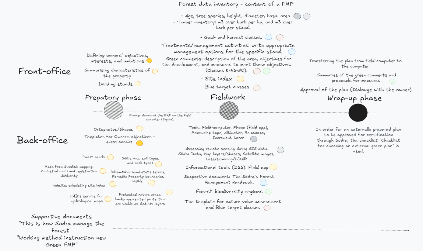
Figure 1A. A summary of the back-and front functions of compiling and completing FMPs.
A2. DECISION TOOLS IN SÖDRA’S PLANNING:
S-plan: a software for planners to create the FMP, using a digital template. External planners hired by Södra normally use a similar software called PCskog.
Field app: An app for employees at Södra. Most commonly used by inspectors (timber buyers) and planners. Inspectors use it when a forest measure is to be carried out on the specific stand, e.g. receiving forest stand data for determining forest management operations and general considerations. Planners may use it, e.g. to compare the current forest status with data in the old plan.
The problem is that some information is not transferred from FMP to this app: property comments (owner’s goals), blue classification and watercourses, point objects added in the FMP (heritage remnants, carbon sinks, consideration areas, presence of certain species, etc.), and suggestions of conservation patches and buffer zones. Some inspectors may overlook important values and features that are described in the FMP.
Min skogsgård – “My forest estate”: An FMP for forest owners in digital format.
Traktdirektivet – Compartment instruction: a document used in forestry to specify how a harvest methods or other activities should be carried out in a specific stand; encompassing everything from soil preparation and pre-commercial thinning to thinning and final felling. Entrepreneurial contractors receive this document from inspectors. The information provided in this instruction document depends on what the inspector considers important to highlight.
A3. GOAL AND HARVEST CLASSIFICATIONS:
Goal classifications are meant to define a long-term management goal with a certain orientation for a specific stand.
PG: production with general consideration.
K: combined objectives, an area where consideration for natural, cultural, and social values is greater than production with general consideration (10-85%).
NS: Nature conservation management, and the conservation area benefiting from management. When referring to set aside stands, you choose between NS or NO.
NO: nature conservation untouched, and the conservation area benefiting from free development. When referring to set-aside stands, the planner chooses between NS or NO.
Harvest classifications are descriptions of the development stage of the forest:
K1: Bare forest land. Regeneration measures are needed.
K2: Bare forest land. Regeneration has been carried out but measures to obtain forests of satisfactory density and quality not carried out to a sufficient extent.
R1 and R2: different stages of pre-commercial thinnings.
G1: Normal thinning forest. Forest younger than minimum forest felling age.
G2: Older thinning forest. Forest that has reached the minimum final felling age, and where the next suitable action is thinning.
S1: Forests that are eligible for harvesting and cannot be classified as S2 or S3. Normally, no harvesting measures are proposed during the planning period.
S2: Forest ready for harvesting.
S3: Final-felling but should not be harvested. Reasons may include conservation considerations, climatic reasons, etc.
E1: Sparse residual stand. A stand that has been left after harvesting or a damaged stand.
E2: Sparse forest stand or land with overgrown with unsuitable tree species.
E3: Pastureland. Sparse forest with pasture characteristics.
A4. TECHNICAL TOOLS (MAPS, SHAPES, WEBSITES, ETC.)[13]
Fornsök (raa.se) Riksantikvarieämbetets service, Fornsök; Property boundaries visible. Descriptions and classifications of ancient sites, other cultural and historical areas are available. Though it is not comprehensive, and not all sites are registered.
Maps from the County Administrative Board, Kartor: CAB’s service for hydrological maps, where the planner can gather information that relates to watercourses.
Maps from Swedish Forest Agency, Kartor: Forest pearls, a map service, reports valuable key biotopes, riparian forests and other nature considerations, as well as heritage remnants. Here, planners can also import stand boundaries and compare them with historical orthophotos. It is also possible to freehand drawing surface and estimate felling volume.
Not updated anymore, the Swedish Forest Agency ceased the registration of key biotopes in connection with a request to do a final felling on a specific stand due to legal disputes and subsequent political decisions.
Maps from Swedish mapping, Cadastral and Land registration Authority, Min Karta, help to easily measure distance to nearby towns to describe where in the landscape the property is located (for property comments). Here, the planner can also view the municipality in which the estate is located, as well as its altitude and latitude.
Forest biodiversity regions: a guiding document that identified important key habitats from a regional perspective. The aim was to facilitate the choice of set-aside areas of Södra members’ estates under planning. A guide for planners to define which habitats/biotopes should be favoured and preserved while preparing suggestions for forest management in a given landscape.
Protected nature, created by the Swedish Environmental Protection Agency, Skyddad natur; different types of landscape-related protection are visible as distinct layers, and in-depth information is available. Property boundaries are visible.
SGUs map, SGUs Kartvisare; this digital map help the planner to reveal the soil types and rock types, and several other maps layers are also available.
Site index, Ståndortsindex - Skogskunskap; calculating site index, and contains information about timber supply tables, etc.
The template for nature value assessment: Indicating what goal class the stand should have, depending on the presence of nature conservation values. The template could be used to prove why planners allocate the stand to NS/NO if there is a misunderstanding. It can be downloaded as a PDF, and then the boxes will automatically be filled in according to the planner’s perceptions of the stand's attributes. While carrying out this questionnaire, walking around and getting an overview of the stand is essential. When the points are compiled, there are suggestions of an appropriate goal class, e.g. “moderately valuable”: when comparing the goal classes, if there is no timber to retrieve and there is a high potential that the stand can increase high natural values in the future, then it becomes a NO/NS.
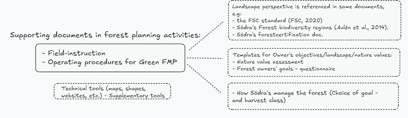
Figure 2A. A summary of support documents from the back-office.
A5. FOREST PLANNING SUPPORT TEMPLATES
Field-instruction: Detailed information on planning requirements, including background materials, data collection using relevant tools, plan contents, required equipment, and communication with the landowner, etc.
Operating procedures for Green FMP: Contains detailed information on how planners should carry out their planning. The planning work currently consists of three main stages: preparatory work, field work, and the wrap-up phase. The work instructions are organised according to these stages.
How Södra’s manage the forest: An abridged edition of the Södra’s Forest Management Handbook. The handbook’s content is guided by Södra’s Forest’s strategic direction for forest management, as well as its guidelines for nature conservation. Provides information about practical forest management measures, such as choice of goal and harvest classifications, a manual with harvest and management templates, etc. The problem is that the information provided is not applicable everywhere. It is based on Södra's standard, based on a "typical property" (which means a homogeneous conifer forest).
A6. EDUCATION
Södra introduced systematic training with the purpose of increasing employees’ knowledge about different forest values and corresponding requirements. Södra offers four educational courses (started two years ago). 1. To convey the advice using words. 2. Blue target classification. 3. Production of broadleaves and close-to-nature forestry (hyggesfritt). 4. Nature value assessment and species knowledge.
FOOTNOTES
[1] Many such countries can be found, for example, in Western and Northern Europe with dominant share of small-scale private forest owners (Forest Europe, 2020) that enjoy large management freedom (Nichiforel et al., 2018)
[2] Green infrastructure refers to a functional ecological network of habitats and structures, where elements are created and managed to maintain biodiversity and provide essential ecosystem services in the landscape.
[3] According to the Swedish Forest Agency (2021), small-scale owners are defined as those holding less than 5000 hectares of forest land.
[4] A valid plan is defined as one that remains applicable throughout its designated planning horizon, which is typically 10 years.
[5] In case of PEFC the requirement to have FMP applies to estates exceeding 20 ha, smaller estate must have maps that document set-asides and other objects of special importance for environmental or social values.
[6] Currently there are three large forest owner associations, operating in south, mid and north of Sweden, respectively. While they label themselves as associations (indicating lobby as core mission), by the profile of activity they rather correspond to forest owners’ cooperatives that pool resources for joint forestry activities.
[7] Indicates the presence of key biotopes in forest area that, based on an overall assessment of the habitats' structure, species composition, history, and current physical environment, is of great importance to the forest's flora and fauna. It contains or can be expected to have red-listed species (SFA, 2020).
[8] A map service reporting valuable key biotopes, riparian forests and other nature considerations, as well as heritage remnants.
[9] Owners' efforts through voluntary set-aside are an important part of the work to preserve high natural values. Voluntary set-aside are areas of productive forest land where owners take responsibility for preserving natural values, cultural environments or social values (SFA, 2025b)
[10] A supportive template for identifying ecological values and indicating what goal class the stand should have regarding the presence of nature conservation attributes (See supplementary material A for more information).
[11] Södra applies the FSC requirement "adapted use" at group certificate level, which means that Södra does not require that there should be 5% adapted use on an individual estate, but must be present on Södra as a whole (applies to estates smaller than 1,000 hectares).
[12] The information provided here is a summary of notes from ethnographic observation of forest planners and inspectors.
[13] Available or suggested to use for forest planner to effectively document the presence of species or cultural heritage remnants within the property or at a landscape level. Notice, not all are used by all planners, and they are not ordered by the degree of usage by planners.
Disclaimer/Publisher’s Note:
The statements, opinions and data contained in all publications are solely those of the individual author(s) and contributor(s) and not of Forest Business Analytics and/or the editor(s). Forest Business Analytics and/or the editor(s) disclaim responsibility for any injury to people or property resulting from any ideas, methods, instructions or products referred to in the content.